Nha trang

Name: Nha Trang is the Vietnaminized version of the Champa name Ya Trang. Ya Trang means “river of reed”, originally used to describe the river Cai and surrounding land.
History
Until the 19th century, Nha Trang was still made up of remote fishing villages, surrounded by jungles and full of wild animals. It was the French that first saw Nha Trang’s prospect as a bathing spot, and quickly put the white sand beaches and clear sea into use. Under French rule, Nha Trang first became town and later township of Khanh Hoa province. During the Vietnam war, Nha Trang grew as a popular holiday destination for American soldiers. During this time, Nha Trang was under the rule of the South Vietnamese government (backed by the US) and was taken over by the National Liberation Front on April 2nd, 1975 (nearly a month before the fall of Saigon). In 1999, Nha Trang officially became a city.
Geography
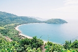
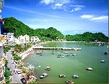
The city of Nha Trang lies in a valley surrounded by mountains on the North, West and Southern side. Nha Trang borders the Pacific ocean on the East. Cai Nha Trang river and Cua Be river divide Nha Trang into three parts, with 19 islands in total. The largest island, Hon Tre is 36km2 large and blocks all wind coming into Nha Trang, giving Nha Trang much less wind and waves.
Further reading
Nha trang weather and climate - information on the best time to visit the city.
Photo by kinjosan .All flickr photos are licensed under the Creative Commons
New Travel Photos Just Added
See the latest travel photos from the VietnamTravelGuide community around the world.


Comment
Write your comment: